 Posted by
Budapest’s bridges make the Danube part of the city rather than a barrier between Buda and Pest. The Chain Bridge is the most famous, but Margaret, Elizabeth and Liberty bridges can be just as useful for a visitor’s route. Farther from the centre, other road and rail bridges serve everyday travel. This guide explains the principal crossings, where to walk for views and why an old claim that there are exactly eleven bridges depends on which structures you count.
At a glance: Danube bridges in Budapest
- Classic central crossing: Széchenyi Chain Bridge.
- For Margaret Island: Margaret Bridge, with an island access branch.
- Near the Great Market Hall: Liberty Bridge.
- For a broad central road crossing: Elizabeth Bridge.
- Most useful on foot: choose the bridge that links sights on your actual route.
- Traffic: rules differ by bridge and can change for events or maintenance.
Why the bridges matter
Budapest occupies both banks of the Danube. Buda’s hills and Castle Quarter face the flatter, densely built centre of Pest. Bridges are therefore essential transport links, but they also structure a visitor’s mental map. Crossing on foot changes the view every minute: Parliament may appear to one side, Castle Hill to another and the next bridge downstream gives a sense of distance.
The first permanent bridge connecting Buda and Pest was the Chain Bridge, opened in 1849. Formal unification of Buda, Pest and Óbuda came in 1873. The old article mixed these dates and said Margaret Bridge opened “only four years” after the Chain Bridge; its opening in the 1870s was roughly a generation later. Correct chronology helps explain the city’s nineteenth-century expansion.
Do not rely on a fixed total without defining the limits. A count can include suburban motorway crossings, railway bridges, two branches around an island or only the well-known central road bridges. For sightseeing, the names and locations are more useful than a disputed number. Our geography guide explains the Danube’s wider route through Hungary.
Chain Bridge: the emblematic crossing
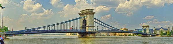
Széchenyi Lánchíd links central Pest with the Buda side below Castle Hill. Its stone towers and suspension chains make it easy to recognise. The pedestrian pavements reopened after a major renovation completed in 2023. The roadway is restricted to permitted traffic rather than open to ordinary private-car through journeys. Follow current signage if travelling by cycle or taxi.
Walking over the bridge is free. A simple crossing is quick, but photographs and viewpoints can turn it into a half-hour stop. On the Buda side you can continue towards the palace district; on the Pest side, towards the riverfront and central squares. Our dedicated Chain Bridge guide covers its history and current use in more detail.
Margaret Bridge and Margaret Island
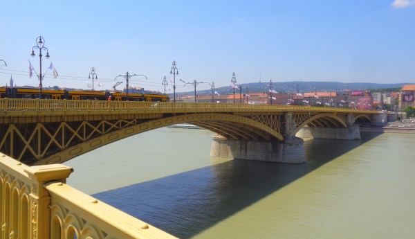
Margaret Bridge lies north of the Chain Bridge and provides a route between the banks with a branch to Margaret Island. This geometry is part of its character: the island is not simply beside the bridge, and you should use the designated access rather than looking for a path down from any point. It is practical if your plan includes the island’s parks and paths.
From the bridge you get different views of Parliament, Castle Hill and the Danube. Traffic and trams also use the crossing, so pedestrians should remain on the designated pavement. The Margaret Island guide helps you plan time on the island itself. A quick bridge crossing and an island visit are not the same duration.
Elizabeth Bridge
Elizabeth Bridge is a broad, modern-looking crossing south of the Chain Bridge. It links central Pest with the Buda side near Gellért Hill and provides an important road connection. For pedestrians, it can be useful as part of a river route, though many visitors prefer other bridges for a leisurely architectural walk. The view down the Danube and back towards the centre changes with your direction and light.
The current bridge replaced an earlier structure destroyed during the Second World War. Several Budapest crossings share a history of wartime destruction and later reconstruction, but their new designs differ. Do not assume every present-day bridge is an unaltered nineteenth-century monument.
Liberty Bridge by the Market Hall
Liberty Bridge stands near Fővám tér and the Great Market Hall. Its green iron structure makes it a distinctive southern-centre crossing. Trams and road traffic use it, with pedestrian routes along the sides. From the bridge you can see the relationship between the market area and the Buda bank.
This bridge is a good choice if your day begins at the Market Hall and continues across the river. Use legal crossings at either end and remain on the pavement; do not sit on railings or step into a tram path for a photograph. Sometimes special events alter traffic arrangements, but a temporary car-free day is not the normal everyday rule.
Other bridges north and south
Árpád Bridge is a major northern crossing and useful for some approaches to Margaret Island or northern districts. Farther north, Megyeri Bridge carries motorway traffic around the metropolitan area and is not a central sightseeing walk. The Újpest railway bridge has a transport role different from the famous central pedestrian routes. Some crossings are better understood from a map or boat than as destinations in themselves.
South of Liberty Bridge, Petőfi Bridge and Rákóczi Bridge connect districts with different visitor and commuter needs. Railway bridges and motorway routes farther out are significant pieces of infrastructure, but they rarely belong on a first-time city walking itinerary. If you are travelling to a specific address across the river, use the route planner instead of choosing a bridge only because it is famous.
Metro lines also cross beneath the Danube, offering an alternative when a bridge walk is too long or the weather poor. M2 and M4 are relevant for central east–west movement. Our Budapest metro guide explains stops and tickets.
Stay near a useful crossing
Central Pest and the Buda riverfront offer different views and walking routes. Check how your hotel connects to the sights you plan to visit, not just its distance from the water.
The bridges and twentieth-century history
During the Second World War, Budapest’s bridges were destroyed, and the city had to rebuild vital connections. The Chain Bridge reopened in 1949, a century after its first opening. Other bridges were repaired or replaced on different timelines. The story is visible in their varied designs today, even though a casual visitor may see only a scenic skyline.
Later road and rail infrastructure responded to a growing city. This is why a bridge list mixes elegant central landmarks and utilitarian outer crossings. Both matter to Budapest, but they serve different travel purposes. A visitor seeking architecture and river views should focus on the centre; a driver on a ring road needs current traffic instructions rather than a sightseeing ranking.
A walking route across two bridges
A straightforward loop begins in central Pest, crosses the Chain Bridge to Buda, follows a public riverside route and returns by Elizabeth Bridge if conditions and walking distance suit you. Another loop links the Great Market Hall, Liberty Bridge and a nearby Buda riverside stretch. Check the street crossings and the total distance before setting off; the river bends and embankment levels can make a route longer than it appears.
If you want Parliament and Margaret Island, Margaret Bridge is a natural choice. A short walk on the bridge does not require an island visit, but the island deserves its own time. The Parliament guide covers nearby sightseeing. Respect the Shoes on the Danube Bank memorial if passing it along the Pest shore.
Seeing bridges from the water
A Danube cruise can give a coherent view of several crossings without a long walk. Choose by departure point, duration, daylight or evening schedule and whether commentary is included. Water levels and weather can change operations. A cruise may pass beneath bridges but will not let you explore their surroundings on foot, so it complements rather than replaces a walking route.
Danube cruises and guided walks
Compare routes carefully: boats depart from different piers and may cover different stretches of river. Check whether a guide explains the bridges or whether the trip is primarily scenic.
Practical advice for bridge walks
Bridges are exposed to sun and wind. Wear suitable shoes and keep to the designated pedestrian area. Do not stop suddenly in a crowded narrow section or lean beyond safety barriers. For photography, the approaches can offer more room than the centre of a busy crossing. At night, choose well-lit public routes and check the last transport connection to your hotel.
Accessibility varies between bridgeheads and nearby embankment levels. The span itself may be fairly level while the approach includes stairs, underpasses or a steep route to Buda’s hill. Plan the whole journey with the public transport guide and current BKK information if you need a step-free route.
Frequently asked questions
Which bridge is most famous?
The Széchenyi Chain Bridge is the classic central image of Budapest. It is one of several bridges worth seeing, and the best crossing depends on your route.
Can I walk across the Chain Bridge?
Yes, normally on its pedestrian pavements. Exceptional event or maintenance closures can occur; check current BKK notices when your itinerary depends on it.
Which bridge leads to Margaret Island?
Margaret Bridge has a branch giving access to the island. Árpád Bridge is another northern approach, but the choice depends on where you start.
How many bridges are there in Budapest?
There is no useful single number without defining the city boundary and whether rail bridges and island branches count separately. For sightseeing, focus on the central crossings listed here.